Atlas AnatoliaAtlas Anatolia
Carnac Stones — France

Carnac Stones

Karnag4500 BCE – 3300 BCE
2

Interest

NeolithicMegalithic EuropeanBrittany

Built

c. 4500–3300 BCE

Civilization

Neolithic communities of Atlantic Europe

Discovered

Known locally; first scientific surveys mid-19th century

Status

UNESCO Tentative List (proposed World Heritage)

Material

Local granite

Number of stones

Over 3,000 menhirs

The Carnac stones offer unparalleled insight into the social organization, cosmology, and engineering capabilities of Neolithic European societies.”

Overview

Discovery

The Carnac stones have been known to local inhabitants for millennia, but systematic archaeological recording began in the eighteenth and nineteenth centuries. The first scholarly accounts appeared in the 1700s, with the earliest surveys conducted by the Scottish antiquary James Miln in the 1860s. Miln meticulously documented the alignments and excavated several tombs, laying the groundwork for subsequent research. His work was continued by Zacharie Le Rouzic, a local archaeologist who devoted his life to studying and preserving the megaliths in the early twentieth century.

Site Layout and Monuments

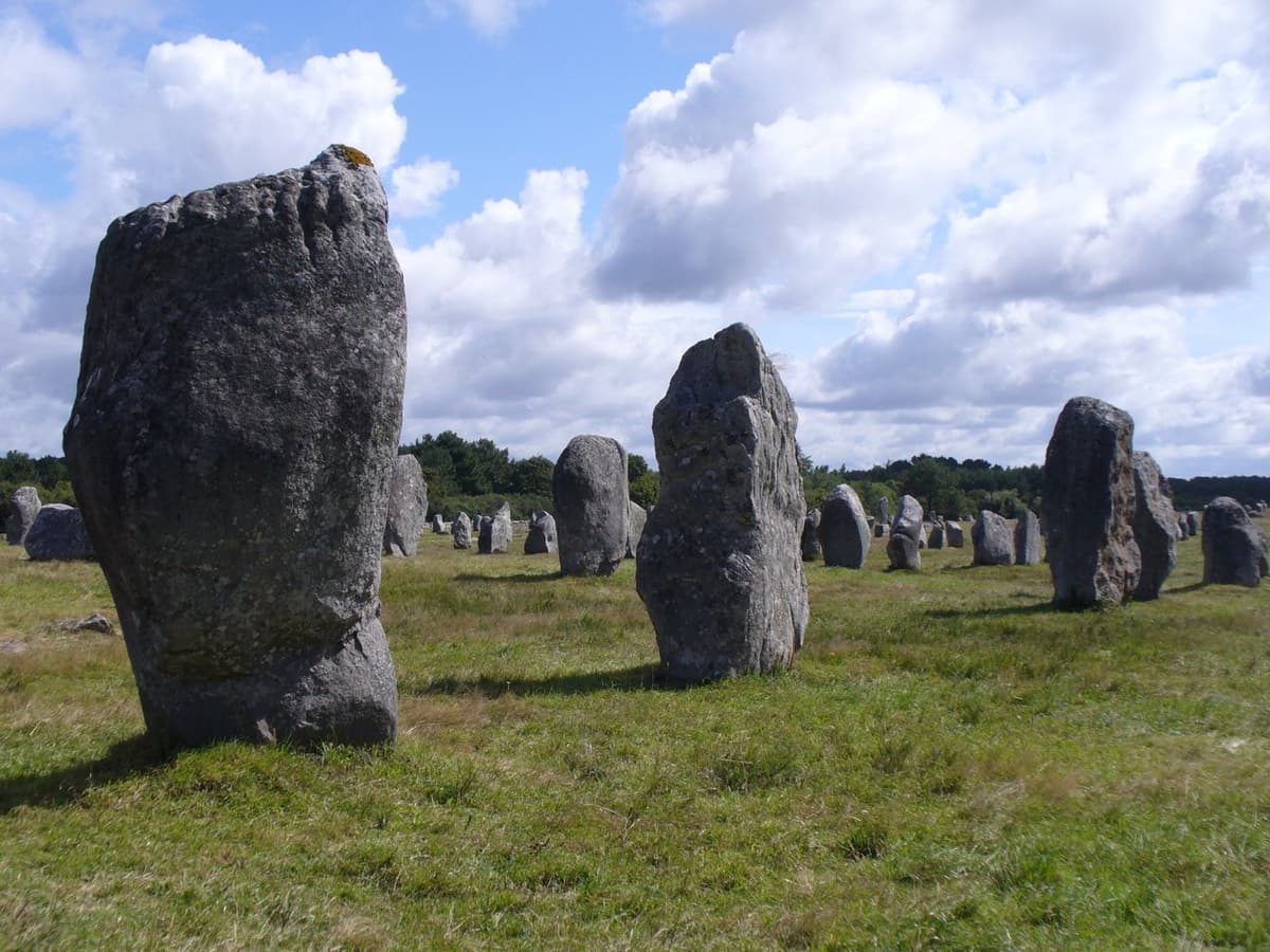
The Carnac complex encompasses multiple discrete alignments—primarily Ménec, Kermario, and Kerlescan—totaling over 3,000 menhirs arranged in parallel rows stretching more than four kilometers. Interspersed among the stones are dolmens (chambered tombs), tumuli (earthen burial mounds), and isolated giant menhirs such as the Grand Menhir Brisé at Locmariaquer. The Ménec alignment begins with a cromlech (stone circle) at its western end, and the rows gradually decrease in height from west to east, suggesting a deliberate architectural plan.

Alignement Menec Carnac

Alignement Menec Carnac | Myrabella (CC BY-SA 3.0)

"Imagine three thousand stones planted in straight lines on the moor, like an army turned to stone — for what god, in honour of what victory, by what people, no man can now tell."
— Prosper Mérimée, Notes d'un voyage dans l'ouest de la France, on the Carnac alignments (1836)

Chronology and Construction

Radiocarbon dating of charcoal and bone from associated contexts indicates that major construction activity occurred between 4500 and 3300 BCE, during the Neolithic period. The stones are hewn from local granite, with some blocks weighing in excess of 300 tons, requiring sophisticated quarrying, transport, and erection techniques. Some evidence suggests that the alignments were built over several centuries, with possible reworking or additions. The sheer scale implies a high degree of social organization and communal labor.

Carnac 56 Alignement du Ménec 2013

*Carnac 56 Alignement du Ménec 2013 | JLPC

(CC BY-SA 3.0)*

Function and Meaning

The purpose of the Carnac stones remains subject to debate. Astronomical interpretations note that certain rows and individual stones align with solstitial and lunar positions, supporting the idea of a ceremonial or calendrical function. Others see them as territorial markers, commemorative monuments for ancestors, or elements of a ritual landscape integrating natural and built features. The presence of nearby tombs and symbols such as axe-heads and shepherd's crooks carved on some stones reinforces a ritual or symbolic dimension.

Conservation and Management

Since the late nineteenth century, the site has faced threats from urbanization, agriculture, and tourism. Many stones have fallen or been removed, and only ongoing conservation efforts by the French state and local authorities protect the surviving alignments. The site is part of the UNESCO Tentative List and is managed as a National Monument, with restricted access during certain seasons and ongoing archaeological research to address erosion and visitor impact.

Why It Matters

The Carnac stones offer unparalleled insight into the social organization, cosmology, and engineering capabilities of Neolithic European societies. As one of the earliest and most extensive monumental landscapes, they challenge assumptions about prehistoric architectural ambition and continue to inspire debates about astronomical knowledge and ritual practice in pre-literate communities.

Stay curious

New stories and sites, once a month. No spam.

Evidence & Interpretation

Distinguishing what is well-established from what remains debated.

Well-Established Facts

3
  • Radiocarbon dating of organic materials from associated contexts places the main phase of construction between 4500 and 3300 BCE.
  • The alignments are composed of over 3,000 stones, arranged in multiple parallel rows extending over 4 kilometers.
  • The stones are made of local granite, with some blocks weighing over 300 tons.

Scholarly Inferences

2
  • The alignments likely had an astronomical function, as several rows align with the winter solstice sunrise and other celestial events.
  • The site functioned as a ritual landscape, possibly for ancestor veneration or community gatherings.

Debated Interpretations

2
  • Interpretations of the alignments as an astronomical observatory versus territorial markers remain contested among scholars.
  • Whether the stones were erected sequentially over centuries or in a few concentrated phases is still unclear.

Discovery & Excavation

1860–1870

Early surveys and excavations

Led by James Miln

James Miln conducted the first systematic archaeological survey and excavations of the Carnac alignments and tombs, documenting many stones and recovering artifacts.

1900–1940

Conservation and restoration

Led by Zacharie Le Rouzic

Zacharie Le Rouzic extensively excavated and restored parts of the alignments, rebuilt fallen menhirs, and campaigned for government protection of the monuments.

1970–1990

Archaeological investigations

Led by Jean L'Helgouach et al.

Teams led by Jean L'Helgouach and others focused on the tumuli, settlement patterns, and landscape context, employing modern scientific techniques.

2000

Ongoing conservation and research

Led by French Ministry of Culture and local authorities

Modern conservation and monitoring programs address erosion, visitor impact, and non-invasive geophysical surveys to better understand subsurface features.

More Photos

Museum Artifacts

Community Photos

Share your experience

Have you visited this site? Upload your photos to help others discover it.

Location

Sources

  • Patton, M. (1993), Statements in Stone: Monuments and Society in Neolithic BrittanyMark Patton (1993)
  • Mohen, J.-P. (2000), The Megaliths of CarnacJean-Pierre Mohen (2000)
  • L'Helgouach, J. (1983), The Carnac Alignments: An Archaeoastronomical PerspectiveJean L'Helgouach (1983)
  • UNESCO Tentative List entry for Carnac megalithic sitesUNESCO World Heritage Centre (1996)Link
  • Roughley, C. (2004), The Neolithic landscape of Carnac: integrating GIS and phenomenologyCorrine Roughley (2004)
  • Scarre, C. (2002), Monuments and Landscape in Atlantic EuropeChris Scarre (2002)

Research Papers

Stay in the loop

Get notified when we add new sites or major features. We send at most 1–2 emails per year. We never sell your email.

Atlas AnatoliaAtlas Anatolia

An interactive atlas of the ancient world. Explore archaeological sites, civilizations, monuments, and stories from every continent.

info@atlasanatolia.com

© 2026 Atlas Anatolia. Content is provided for educational purposes.

Map data © OpenStreetMap contributors