Atlas AnatoliaAtlas Anatolia
Mohenjo-daro — Pakistan

Mohenjo-daro

موئن جو دڙو2500 BCE – 1700 BCE
8

Interest

Bronze AgeIndus ValleySindh

Built

c. 2500 BCE, with earlier occupation

Civilization

Indus Valley (Harappan) Civilization

Discovered

1922 by R. D. Banerji

Peak Population

Approximately 40,000

Abandoned

c. 1700 BCE, gradual decline

Status

UNESCO World Heritage Site since 1980

Mohenjo-daro challenges traditional narratives of early urbanism by demonstrating that large, complex cities could flourish without monumental temples or royal iconography.”

Overview

Discovery and Early Excavations

Mohenjo-daro was discovered in 1922 by R. D. Banerji of the Archaeological Survey of India. Recognizing its antiquity, systematic excavations began under Sir John Marshall in 1924–25, revealing an extraordinary ancient city. Subsequent campaigns by E. J. H. Mackay (1927–1931) and Sir Mortimer Wheeler (1950) exposed extensive areas of the lower town and citadel. Wheeler’s deep soundings contributed to understanding the site’s chronology, confirming occupation from approximately 2500 to 1700 BCE. Since Pakistani independence, the Department of Archaeology and Museums and international teams have continued limited excavations and extensive conservation work.

Urban Planning and Architecture

The city displays a highly organized layout unique for its time. A raised citadel to the west housed monumental structures, including the famous ‘Great Bath’—a waterproofed brick tank interpreted as a ritual bathing pool—and a large granary or assembly hall. The lower city was laid out on a grid pattern of streets aligned with the cardinal directions. Residential blocks featured standardized fired-brick houses with flat roofs, internal courtyards, and private wells. The most remarkable feature is an elaborate drainage system: every house had a bathroom and toilet connected to covered drains along the streets with manholes for cleaning, indicating advanced municipal governance and concern for hygiene.

Mohenjo-daro
Mohenjo-daro

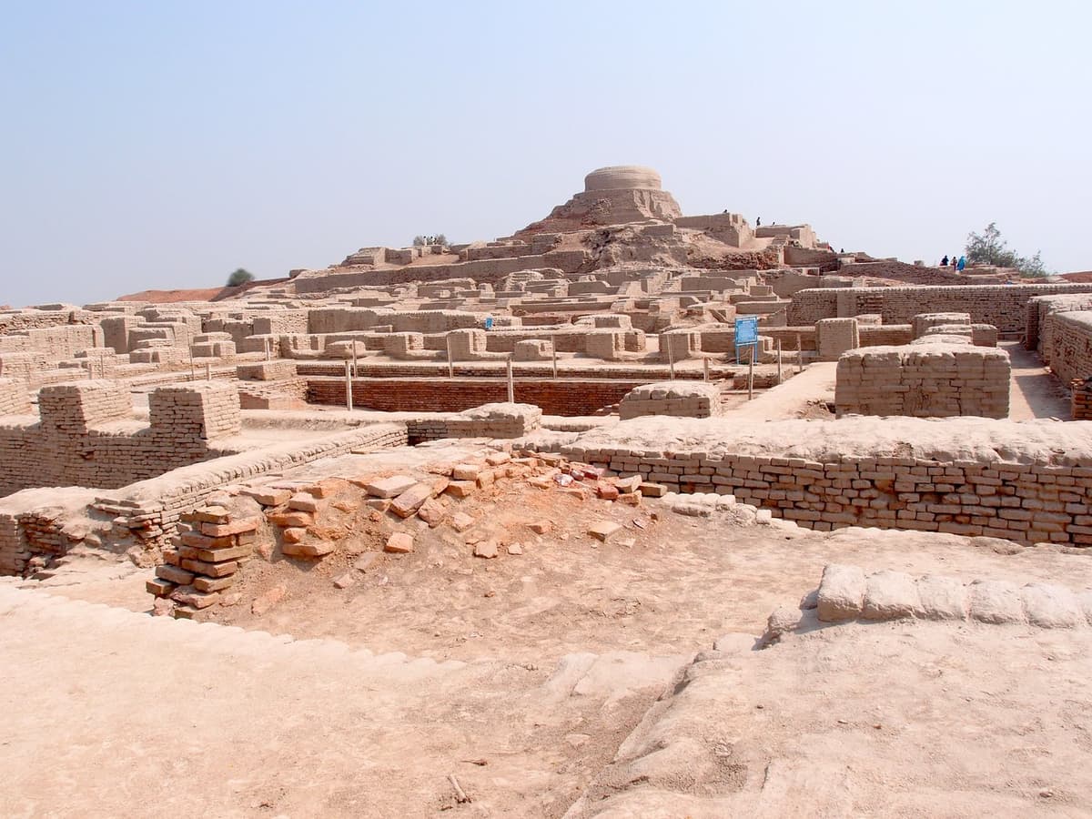
Mohenjo-daro | Saqib Qayyum (CC BY-SA 3.0)

"Not often has it been given to archaeologists, as it was given to Schliemann at Tiryns and Mycenae, or to Stein in the deserts of Turkestan, to light upon the remains of a long-forgotten civilization."
— John Marshall, announcing the discovery of the Indus Valley civilization, Illustrated London News, 20 September 1924

Society and Economy

The lack of ostentatious palaces or royal burials at Mohenjo-daro suggests a society governed less by a single ruler and more by a corporate elite or council. Material culture, including seals, pottery, and figurines, points to a complex economy with trade links extending to Mesopotamia, the Persian Gulf, and Central Asia. Standardized weights and measures, along with ubiquitous stamp seals inscribed with the still-undeciphered Indus script, imply well-regulated commerce and administrative control. Craft specialization is evident in workshops for bead-making, shell-working, and metal production, while agricultural surpluses came from the fertile Indus floodplain.

Great bath view Mohenjodaro

Great bath view Mohenjodaro | Saqib Qayyum (CC BY-SA 3.0)

Decline and Abandonment

Around 1900 BCE, Mohenjo-daro began a gradual decline before final abandonment. Theories about the cause remain debated. Environmental factors, such as shifts in the Indus river course leading to floods or reduced water availability, likely played a role. Some archaeologists propose climate change and decreased monsoonal rainfall, while others point to tectonic activity altering the landscape. Claims of an Aryan invasion have been largely discredited; evidence shows no widespread destruction. The site’s final occupation layers show a deterioration in urban maintenance and a possible reduction in population, suggesting a protracted process rather than a sudden catastrophe.

Significance

Mohenjo-daro is the best-preserved urban settlement of the Indus Valley Civilization and provides the clearest evidence of pre-Harappan and Harappan urbanism. Its inclusion on the UNESCO World Heritage list in 1980 underscores its outstanding universal value. The site continues to yield insights into early state formation, non-Western urbanism, and sustainable water management, making it a touchstone for understanding the ancient world.

Why It Matters

Mohenjo-daro challenges traditional narratives of early urbanism by demonstrating that large, complex cities could flourish without monumental temples or royal iconography. Its advanced sanitation systems predate comparable Roman infrastructure by nearly 2,000 years. The undeciphered Indus script and the city’s enigmatic decline continue to drive scholarly inquiry into the nature of ancient civilizational collapse.

Stay curious

New stories and sites, once a month. No spam.

Evidence & Interpretation

Distinguishing what is well-established from what remains debated.

Well-Established Facts

3
  • Mohenjo-daro’s street grid and brick sizes follow a standardized ratio, indicating centralized planning.
  • Advanced drainage systems connected every house, with covered drains and manholes, demonstrating sophisticated sanitation engineering.
  • The Great Bath is a waterproofed brick structure with steps, likely used for ritual purification.

Scholarly Inferences

2
  • The absence of grand palaces or temples suggests a corporate or egalitarian governance structure rather than a monarchy.
  • Trade with Mesopotamia is strongly indicated by Indus-style seals found in Sumerian cities and mentions of Meluhha in cuneiform texts.

Debated Interpretations

2
  • The primary cause of the city’s decline remains contested, with hypotheses ranging from river migration to climate change and socioeconomic factors.
  • The function and meaning of the undeciphered Indus script remain unknown, with debate over whether it represents a full language or a limited sign system.

Discovery & Excavation

1922–1927

Initial discovery and first systematic excavations

Led by R. D. Banerji, Sir John Marshall

R. D. Banerji identified the site, followed by large-scale excavations under Sir John Marshall starting in 1924, unearthing the citadel and lower town.

1927–1931

Major horizontal excavations

Led by E. J. H. Mackay

E. J. H. Mackay expanded excavations, exposing significant residential and public areas and recovering many artifacts.

1950–1950

Deep sounding and chronology

Led by Sir Mortimer Wheeler

Sir Mortimer Wheeler conducted a deep stratigraphic trench to establish the site’s chronology and investigate fortifications; his work refined dating and identified a possible flood layer.

1979–1985

Conservation-focused project

Led by Michael Jansen, Maurizio Tosi

A UNESCO–UNDP project focused on preserving exposed structures, documentation, and training Pakistani archaeologists, with limited new excavation.

2015

Recent conservation and non-invasive surveys

Led by Government of Pakistan, international research teams

Using ground-penetrating radar and 3D scanning to map subsurface features and monitor structural decay, coupled with targeted conservation of the Great Bath and other monuments.

More Photos

Museum Artifacts

Community Photos

Share your experience

Have you visited this site? Upload your photos to help others discover it.

Location

Sources

  • Marshall, J. (1931). Mohenjo-daro and the Indus CivilizationJohn Marshall (1931)
  • Kenoyer, J. M. (1998). Ancient Cities of the Indus Valley CivilizationJonathan Mark Kenoyer (1998)
  • Possehl, G. L. (2002). The Indus Civilization: A Contemporary PerspectiveGregory L. Possehl (2002)
  • Jansen, M. (1989). ‘Water Supply and Sewage Disposal at Mohenjo-daro.’ World Archaeology, 21(2), 177–192.Michael Jansen (1989)
  • UNESCO World Heritage List: Archaeological Ruins at MoenjodaroLink

Research Papers

Stay in the loop

Get notified when we add new sites or major features. We send at most 1–2 emails per year. We never sell your email.

Atlas AnatoliaAtlas Anatolia

An interactive atlas of the ancient world. Explore archaeological sites, civilizations, monuments, and stories from every continent.

info@atlasanatolia.com

© 2026 Atlas Anatolia. Content is provided for educational purposes.

Map data © OpenStreetMap contributors