Atlas AnatoliaAtlas Anatolia
Pasargadae — Iran

Pasargadae

پاسارگاد546 BCE – 330 BCE
2

Interest

ClassicalAchaemenid PersianFars Province

Built

c. 546 BCE

Civilization

Achaemenid Persian

Discovered

Modern excavations began 1908 by Ernst Herzfeld

Status

UNESCO World Heritage Site (inscribed 2004)

Founder

Cyrus the Great

Function

Ceremonial and dynastic capital, royal garden complex

Pasargadae embodies the foundational moment of the Achaemenid Empire, marking the shift from regional power to world empire.”

Overview

Historical Context

Pasargadae was founded by Cyrus the Great around 546 BCE on the fertile plain of the Pulvar River, following his conquest of the Median Empire. It served as the ceremonial and administrative nucleus of the nascent Achaemenid dynasty, embodying the ideological synthesis of Elamite, Mesopotamian, and Iranian traditions. The city remained a sacred dynastic center even after the capital moved to Persepolis under Darius I. Its abandonment accelerated after Alexander the Great’s invasion in 330 BCE, though the tomb of Cyrus continued to be venerated for centuries.

Discovery and Excavation

Early European travelers, such as Josafa Barbaro in 1474 and Carsten Niebuhr in 1765, noted the ruins, but systematic archaeological investigation began in 1908 with Ernst Herzfeld. Herzfeld’s work, continued in 1928, produced the first detailed plans and photographs. The most comprehensive excavations were undertaken by David Stronach from 1961 to 1963 on behalf of the British Institute of Persian Studies, which revealed the palace complex, gardens, and fortifications. Later Iranian teams led by Ali Sami and subsequent conservation efforts have focused on preservation and restoration.

Tomb of Cyrus the Great

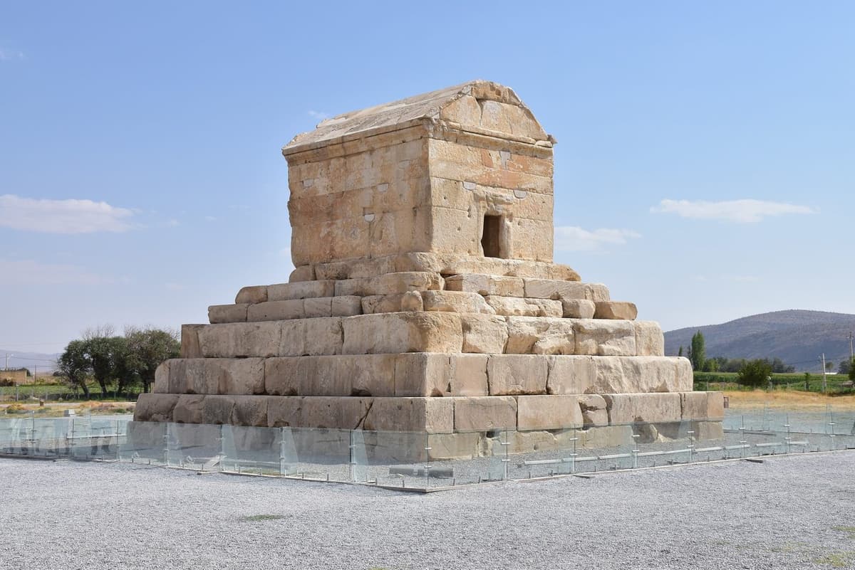
Tomb of Cyrus the Great | Mohammad Reza Domiri Ganji محمدرضا دومیری گنجی (CC BY-SA 4.0)

"O man, whoever you are and wherever you come from — I am Cyrus, who founded the empire of the Persians. Do not therefore grudge me this little earth which covers my body."
— Inscription on the Tomb of Cyrus the Great at Pasargadae, recorded by Strabo, Geography XV.3.7

Architectural Significance

The site’s layout reflects an innovative open-plan design, with palace pavilions, audience halls, and a tomb set within a vast garden—the earliest known royal park or ‘paradise’ (from Old Persian paridaida). The structures employ a characteristic blend of architectural traditions: Ionian Greek stone-working techniques, Assyrian lamassu-style guardian figures, and Urartian rock-cut tombs. The use of white limestone columns with black stone bases and capitals influenced later Achaemenid architecture at Persepolis and Susa.

CyrustheGreatTomb 22059

CyrustheGreatTomb 22059 | Truth Seeker (CC BY-SA 3.0)

The Tomb of Cyrus

A modest gabled tomb on a stepped platform, traditionally attributed to Cyrus based on Greek historians’ descriptions and a long-lost inscription, stands as the focal point of the site. The structure measures about 11 meters in height and was once surrounded by a colonnade. Its restrained design contrasts sharply with later royal tombs, likely reflecting Cyrus’s personal ethos. Inscribed on the tomb, according to Arrian, was the plea: ‘O man, I am Cyrus… grudge me not therefore this monument.’

Royal Complex and Monuments

The palace area includes the Residential Palace (Palace P), the Gatehouse (Gate R) with its famous four-winged guardian figure, and the Audience Hall (Palace S). The Zendan-e Suleiman, a towering stone structure of debated function (possibly a tomb or fire temple), punctuates the northern precinct. The Tall-e Takht, a massive stone platform overlooking the plain, likely served as a fortified citadel. These monuments illustrate the early Achaemenid experimental phase in monumental construction, prior to the mature forms seen at Persepolis.

Pasargadae ruins
Pasargadae ruins

Pasargadae ruins | A. Davey (CC BY 2.0)

Legacy and Interpretation

Pasargadae remains central to debates on the nature of Achaemenid kingship and urbanism. While some scholars see it as a fully-fledged capital, others interpret it as a dynastic sanctuary and coronation site. Its planned gardens and multicultural artistry underscore Cyrus’s vision of a universal empire. Today, as a UNESCO World Heritage Site, Pasargadae provides crucial evidence for understanding the origins of Persian imperial ideology and its enduring influence on the ancient world.

Why It Matters

Pasargadae embodies the foundational moment of the Achaemenid Empire, marking the shift from regional power to world empire. Its architectural and urban innovations set the template for later Persian capitals and spread the concept of the royal garden across Eurasia. The site offers vivid testimony to Cyrus the Great’s policy of cultural synthesis and tolerance, which resonates in later traditions of Persian kingship.

Stay curious

New stories and sites, once a month. No spam.

Evidence & Interpretation

Distinguishing what is well-established from what remains debated.

Well-Established Facts

3
  • The tomb of Cyrus is securely identified based on descriptions by Greek historians (Arrian, Strabo) and its unique architectural form.
  • Inscribed fragments and the Cyrus Cylinder confirm the use of multilingual proclamations and the promotion of Cyrus’s tolerance.
  • Excavations revealed an extensive irrigation system and garden layout, the oldest known royal paradise (paridaida).

Scholarly Inferences

2
  • The four-winged guardian figure at Gate R likely represents Cyrus the Great, blending Egyptian, Elamite, and Assyrian iconography to symbolize universal rule.
  • The palace layout with isolated pavilions within a garden reflects a ceremonial rather than residential function, possibly used for audience and ritual.

Debated Interpretations

2
  • The function of the Zendan-e Suleiman remains disputed: interpretations range from a tomb for Cambyses to a fire temple or treasury.
  • Scholars disagree on whether Pasargadae was the primary administrative capital or solely a sacred dynastic center, with royal administration concentrated elsewhere.

Discovery & Excavation

Modern conservation and monitoring

Led by Various Iranian and international teams

Ongoing collaborative projects involving the Iranian Cultural Heritage Organization and international partners focus on stabilization, environmental monitoring, and addressing structural issues, particularly at the Tomb of Cyrus.

1908–1928

Initial Scientific Survey and Excavations

Led by Ernst Herzfeld

Ernst Herzfeld conducted the first systematic mapping, photography, and excavations, documenting the major monuments and recovering architectural fragments.

1950–1958

Conservation and Iranian Investigations

Led by Ali Sami

Ali Sami and the Iranian Antiquities Service carried out restoration and further investigations, consolidating structures and preparing the site for visitors.

1961–1963

Comprehensive Excavations of the Royal Complex

Led by David Stronach

David Stronach led the British Institute of Persian Studies’ excavations, revealing the palace plan, gardens, water channels, and artifacts, forming the basis of modern understanding of the site.

More Photos

Museum Artifacts

Community Photos

Share your experience

Have you visited this site? Upload your photos to help others discover it.

Location

Sources

  • Stronach, D. (1978) Pasargadae: A Report on the Excavations Conducted by the British Institute of Persian Studies from 1961 to 1963David Stronach (1978)
  • Briant, P. (2002) From Cyrus to Alexander: A History of the Persian EmpirePierre Briant (2002)
  • Stronach, D. (1990) 'The Garden as a Political Statement: Some Case Studies from the Near East in the First Millennium B.C.', Bulletin of the Asia InstituteDavid Stronach (1990)
  • Root, M.C. (1979) 'The King and Kingship in Achaemenid Art: Essays on the Creation of an Iconography of Empire', Acta IranicaMargaret Cool Root (1979)
  • UNESCO World Heritage List: PasargadaeLink
  • Encyclopaedia Iranica: PasargadaeLink

Research Papers

Stay in the loop

Get notified when we add new sites or major features. We send at most 1–2 emails per year. We never sell your email.

Atlas AnatoliaAtlas Anatolia

An interactive atlas of the ancient world. Explore archaeological sites, civilizations, monuments, and stories from every continent.

info@atlasanatolia.com

© 2026 Atlas Anatolia. Content is provided for educational purposes.

Map data © OpenStreetMap contributors