Atlas AnatoliaAtlas Anatolia
Petra — Jordan

Petra

البتراء300 BCE – 700 CE
22

Interest

HellenisticRomanLate AntiqueNabataeanRomanByzantineMa'an Governorate

Built

circa 300 BCE – 700 CE

Civilization

Nabataean Kingdom, later Roman and Byzantine

Discovered

Known locally for centuries; reintroduced to Western world by Johann Ludwig Burckhardt in 1812

Status

UNESCO World Heritage Site (1985) and one of the New Seven Wonders of the World (2007)

Alternative Name

Raqmu (Nabataean name)

Key Structures

Al-Khazneh (the Treasury), Ad-Deir (the Monastery), the Siq, and 800+ carved monuments

Petra embodies the crossroads of ancient civilizations, where Nabataean, Hellenistic, and Roman influences merged to create a unique architectural and cultural legacy.”

Overview

Discovery

Petra was known to local Bedouins for centuries but remained hidden from the Western world until Swiss explorer Johann Ludwig Burckhardt rediscovered it in 1812. Disguised as a pilgrim, Burckhardt convinced his guide to lead him to the legendary 'lost city,' becoming the first European in over 500 years to document its monumental facades.

Significance

As the capital of the Nabataean Kingdom, Petra flourished between 300 BCE and 106 CE, controlling vital trade routes that connected Arabia, Egypt, and the Mediterranean. Its strategic position allowed the Nabataeans to amass wealth, which they channeled into carving elaborate tombs and temples directly into the rose-red sandstone cliffs. After Roman annexation in 106 CE, the city continued to prosper until a series of earthquakes and shifts in trade routes led to its gradual abandonment by the 8th century.

Al Khazneh Petra edit 2

*Al Khazneh Petra edit 2 | Al_Khazneh_Petra.jpg: Graham Racher from London, UK

derivative work: MrPanyGoff (CC BY-SA 2.0)*

"Match me such marvel save in Eastern clime, a rose-red city half as old as time."
— John William Burgon, "Petra," Newdigate Prize poem, 1845

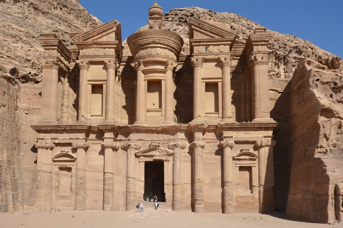
Architecture and Water Management

The iconic Al-Khazneh (the Treasury) and Ad-Deir (the Monastery) exemplify a unique fusion of Hellenistic, Roman, and indigenous Nabataean styles. Carved in the 1st century CE, these monuments likely served as tombs or religious structures. Equally remarkable is the hydraulic engineering system: dams, cisterns, and ceramic pipelines collected and distributed water, protecting the city from flash floods while sustaining a population estimated at 20,000–30,000.

The Treasury, Petra, Jordan5

The Treasury, Petra, Jordan5 | Diego Delso (CC BY-SA 3.0)

Society and Religion

The Nabataeans worshipped a pantheon of deities, with Dushara as the supreme god. Inscriptions and rock-cut shrines throughout Petra attest to religious practices that blended Arabian and Greco-Roman traditions. Women may have held significant economic roles, as suggested by tomb ownership inscriptions, though the exact nature of their status remains debated. Under Byzantine rule, parts of Petra were repurposed, with the Urn Tomb converted into a church.

Decline and Legacy

Destructive earthquakes in 363 and 551 CE, coupled with the rise of maritime trade routes, triggered Petra’s slow decline. By the 7th century, the city was largely deserted, remembered only in legend until its modern rediscovery. Today, Petra stands as a testament to the ingenuity of the Nabataeans and the intercultural exchanges that shaped the ancient Near East.

Why It Matters

Petra embodies the crossroads of ancient civilizations, where Nabataean, Hellenistic, and Roman influences merged to create a unique architectural and cultural legacy. Its ingenious water system showcases early sustainable urban planning, while its role in the incense trade highlights the interconnected economies of the ancient world.

Stay curious

New stories and sites, once a month. No spam.

Evidence & Interpretation

Distinguishing what is well-established from what remains debated.

Well-Established Facts

3
  • Petra's water management system included dams, cisterns, and ceramic pipelines that provided a stable water supply and prevented flooding.
  • Al-Khazneh was carved in the 1st century CE, likely as a royal tomb, and not a treasury as later folklore suggested.
  • The Nabataeans controlled the lucrative incense trade routes from southern Arabia to the Mediterranean, generating immense wealth.

Scholarly Inferences

2
  • Major earthquakes in 363 and 551 CE caused catastrophic structural damage, accelerating the city's abandonment.
  • The so-called 'Great Temple' complex likely served both religious and civic functions, though its exact purpose remains uncertain.

Debated Interpretations

2
  • The function of the Monastery (Ad-Deir) is disputed, with interpretations ranging from a temple, a royal tomb, or a meeting hall for religious associations.
  • The degree of female agency in Nabataean society is contested, with some inscriptions suggesting women could own tombs and manage property.

Discovery & Excavation

Modern conservation

Led by Jordanian Department of Antiquities and UNESCO

Ongoing conservation and site management by the Jordanian Department of Antiquities and international partners, addressing tourism impact and structural stability.

1812

Rediscovery by Johann Ludwig Burckhardt

Led by Johann Ludwig Burckhardt

Burckhardt's visit marks the beginning of modern Western awareness of Petra, although no formal excavations were conducted.

1929–1930

First systematic excavations

Led by George Horsfield and Agnes Conway

George Horsfield and Agnes Conway conducted the first scientific archaeological work at Petra, focusing on the city center and tombs.

1958–1964

British School of Archaeology expeditions

Led by Diana Kirkbride and Peter Parr

Diana Kirkbride and Peter Parr excavated key areas, including the Colonnaded Street and the Petra Church, uncovering important Byzantine-era mosaics.

1992–2002

Brown University excavations of the Great Temple

Led by Martha Sharp Joukowsky

Martha Sharp Joukowsky led extensive excavations of the Great Temple complex, revealing its monumental architecture and diverse use over centuries.

More Photos

Museum Artifacts

Community Photos

Share your experience

Have you visited this site? Upload your photos to help others discover it.

Location

Sources

  • Taylor, J. (2001), Petra and the Lost Kingdom of the NabataeansJane Taylor (2001)
  • Joukowsky, M. S. (1998), "The Petra Great Temple: A Nabataean Architectural Miracle"Martha S. Joukowsky (1998)
  • Orthodox, R. (2016), "The Water Supply System of Petra"Robert Orthodox (2016)
  • UNESCO World Heritage entry – PetraLink
  • McKenzie, J. (1990), The Architecture of PetraJudith McKenzie (1990)
  • Schmid, S. G. (2007), "The International Aṣlaḥ Project: Excavations at Petra"Stephan G. Schmid (2007)

Research Papers

Stay in the loop

Get notified when we add new sites or major features. We send at most 1–2 emails per year. We never sell your email.

Atlas AnatoliaAtlas Anatolia

An interactive atlas of the ancient world. Explore archaeological sites, civilizations, monuments, and stories from every continent.

info@atlasanatolia.com

© 2026 Atlas Anatolia. Content is provided for educational purposes.

Map data © OpenStreetMap contributors