Atlas AnatoliaAtlas Anatolia
Skara Brae — United Kingdom

Skara Brae

3180 BCE – 2500 BCE
4

Interest

NeolithicMegalithic EuropeanOrkney Islands

Built

c. 3180 BCE

Civilization

Neolithic Orkney, part of the Grooved Ware culture

Discovered

Exposed by a storm in 1850, first excavated by William Watt

Status

Part of the Heart of Neolithic Orkney UNESCO World Heritage Site (inscribed 1999)

Abandonment

Site abandoned c. 2500 BCE, likely due to coastal encroachment or climatic shift

Layout

Eight stone houses with standardized furniture, connected by covered passageways

Skara Brae provides a rare, complete picture of Neolithic life, predating Stonehenge and the Pyramids of Giza, and challenges assumptions about the technological and social sophistication of prehistoric communities.”

Overview

Discovery

In the winter of 1850, a fierce storm stripped the turf from a high sand dune on the Bay of Skaill, revealing the stone walls of an ancient settlement. Local laird William Watt conducted the first excavations, uncovering four houses and a wealth of artifacts. The true significance of the site, however, remained unrecognized until V. Gordon Childe’s extensive campaign from 1928 to 1930, which exposed the full layout and established its Neolithic date—overturning earlier attributions to the Iron Age.

"A great storm in the winter of 1850 stripped the grass from a high knoll on the Bay of Skaill, and revealed beneath it the stone-built houses of a forgotten people. The dwellings stood almost as their inhabitants had left them."
— William Watt of Skaill, on the storm that uncovered Skara Brae, recorded in the New Statistical Account of Scotland (1851)
Skara Brae neolithic village, Mainland, Orkney - geograph.org.uk - 3186326

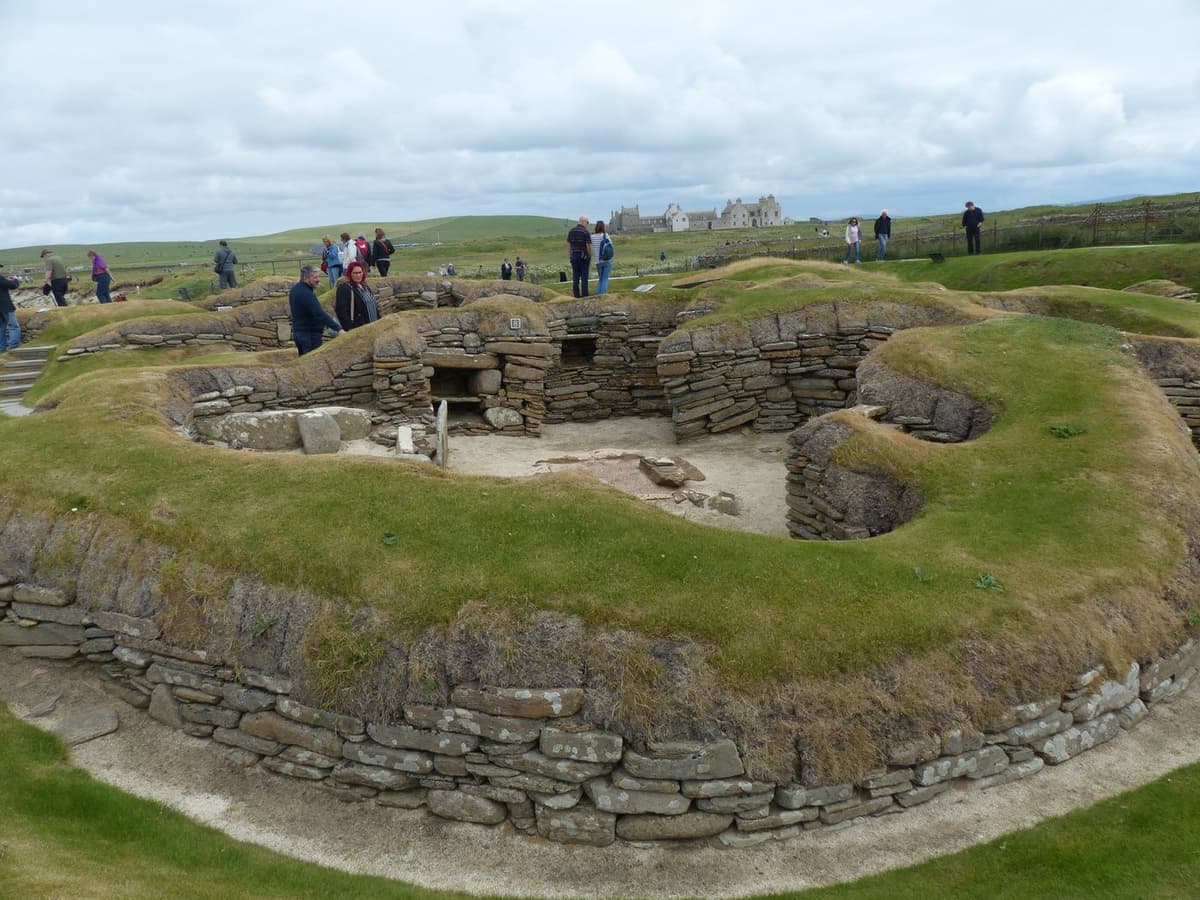
Skara Brae neolithic village, Mainland, Orkney - geograph.org.uk - 3186326 | Christopher Hilton  (CC BY-SA 2.0)

Environment and Setting

Skara Brae occupies a coastal terrace overlooking the Atlantic Ocean, originally set back from the shore beside a small freshwater loch. The village was built upon an existing midden, a deliberate choice that provided insulation and stability amidst the harsh Orcadian climate. Radiocarbon dates place its occupation between c. 3180 and 2500 BCE, a period during which sea levels were lower and the site lay inland. Gradual coastal erosion eventually brought the sea to its doorstep, contributing to its abandonment.

Architecture and Layout

Within Skara Brae, Orkney - geograph.org.uk - 6725811

Within Skara Brae, Orkney - geograph.org.uk - 6725811 | Julian Paren  (CC BY-SA 2.0)

The settlement comprises eight stone-built houses linked by covered alleyways, representing the apex of Neolithic domestic architecture. Each dwelling follows a uniform plan: a single room with a central hearth, a stone “dresser” set opposite the entrance, and bed compartments built into the walls. The precise, modular construction in local flagstone, complete with drainage systems and possible locking mechanisms, points to a highly organized community. The standardized layout suggests shared cultural norms and perhaps a symbolic ordering of domestic space.

Material Culture

Skara Brae, Replica Neolithic Dwelling - geograph.org.uk - 6979893

Skara Brae, Replica Neolithic Dwelling - geograph.org.uk - 6979893 | David Dixon  (CC BY-SA 2.0)

Excavations have yielded a rich assemblage, most notably Grooved Ware pottery, which emerged in Orkney and spread across Britain and Ireland. Other finds include exquisitely carved stone balls, tools of bone and antler, and evidence of local manufacturing. The inhabitants subsisted on domesticated cattle and sheep, supplemented by barley cultivation and marine resources. The striking absence of obvious weaponry and the presence of finely decorated objects indicate a society that valued craft and possibly ceremonial expression over conflict.

Significance

Skara Brae is the most complete Neolithic village in Europe, frequently dubbed the “Scottish Pompeii.” Its preservation allows archaeologists to study prehistoric daily life in minute detail—from household routines to community planning. As part of the Heart of Neolithic Orkney World Heritage Site, it stands alongside the monumental structures of Maeshowe, the Stones of Stenness, and the Ring of Brodgar, revealing a complex, interconnected landscape where the domestic and the ritual were deeply entwined.

Why It Matters

Skara Brae provides a rare, complete picture of Neolithic life, predating Stonehenge and the Pyramids of Giza, and challenges assumptions about the technological and social sophistication of prehistoric communities. Its architecture and material culture highlight a complex society integrated with the broader ceremonial landscape of Orkney.

Stay curious

New stories and sites, once a month. No spam.

Evidence & Interpretation

Distinguishing what is well-established from what remains debated.

Well-Established Facts

3
  • The settlement was built in two main phases, with the earliest structures founded directly on a pre-existing midden.
  • Each house contains a central hearth, a stone dresser, and bed compartments, demonstrating a consistent architectural template.
  • Artifacts include Grooved Ware pottery, carved stone balls, and bone and antler tools, indicating local production and long-distance exchange.

Scholarly Inferences

2
  • The uniform orientation and arrangement of furniture imply a shared cosmology or social order, with domestic space structured by symbolic principles.
  • The deliberate use of midden material for insulation reflects sophisticated environmental adaptation to the windy coastal setting.

Debated Interpretations

3
  • The function of carved stone balls remains uncertain, with interpretations ranging from weapons to symbols of authority or ritual objects.
  • The precise cause of the village’s abandonment—whether climatic deterioration, loss of land to the sea, or social change—is still contested.
  • The extent to which Skara Brae’s inhabitants participated in the rituals at nearby monuments like the Ring of Brodgar is unclear, though the contemporaneity suggests some connection.

Discovery & Excavation

Modern conservation and monitoring

Led by Historic Environment Scotland

Historic Environment Scotland manages ongoing conservation, monitoring cliff recession and visitor impacts, with periodic non-invasive surveys and limited targeted excavations.

1850

Initial discovery and excavation

Led by William Watt

After a severe storm stripped turf from the dune, local laird William Watt uncovered four stone houses and collected numerous artifacts, though the prehistoric date was not yet recognised.

1928–1930

Major excavation by Gordon Childe

Led by V. Gordon Childe

V. Gordon Childe directed a full excavation, exposing the entire village, recording finds in detail, and establishing a Neolithic chronology through ceramic typology—correcting earlier Iron Age attributions.

1972–1973

Conservation and further investigation

Led by David V. Clarke

David V. Clarke conducted rescue and research excavations to address coastal erosion, recover environmental remains from the midden, and produce the first radiocarbon dates for the site.

More Photos

Museum Artifacts

Community Photos

Share your experience

Have you visited this site? Upload your photos to help others discover it.

Location

Sources

  • Childe (1931), Skara Brae: A Pictish Village in OrkneyV. Gordon Childe (1931)
  • Clarke and Maguire (1989), Skara Brae: Northern Europe's Best Preserved Neolithic VillageDavid Clarke and Patrick Maguire (1989)
  • Richards (2005), Dwelling among the monuments: the Neolithic village of Barnhouse, Maeshowe and Skara BraeColin Richards (2005)
  • Clarke (1976), The Neolithic Village at Skara Brae, Orkney: 1972-73 ExcavationsDavid V. Clarke (1976)
  • Ritchie (1995), Prehistoric OrkneyAnna Ritchie (1995)
  • Heart of Neolithic Orkney UNESCO World Heritage List entryLink

Research Papers

Stay in the loop

Get notified when we add new sites or major features. We send at most 1–2 emails per year. We never sell your email.

Atlas AnatoliaAtlas Anatolia

An interactive atlas of the ancient world. Explore archaeological sites, civilizations, monuments, and stories from every continent.

info@atlasanatolia.com

© 2026 Atlas Anatolia. Content is provided for educational purposes.

Map data © OpenStreetMap contributors