Atlas AnatoliaAtlas Anatolia
Van Fortress (Tushpa) perched on rock overlooking Lake Van

Tushpa (Van Fortress)

Van Kalesi900 BCE – 600 BCE
1

Interest

W 1K
Iron AgeUrartianVan

Fortress Length

~1,800 meters along the rock

Key Inscription

Sarduri I — oldest Urartian text (c. 840 BCE)

Menua Channel

50+ km aqueduct, parts still functioning

Period

9th-7th century BCE — capital of Urartu

Primary Construction Material

Massive limestone blocks, some weighing up to 20 tons, used for the cyclopean masonry of the fortress walls.

Major Destruction Event

Sack of Tushpa by the Median king Cyaxares, c. 590 BCE, marking the end of Urartu as an independent kingdom.

Tushpa is the defining monument of Urartian civilization — a kingdom that rivaled Assyria for dominance of the ancient Near East during the 9th-7th centuries BCE.”

WFrom Wikipedia

Tushpa was the capital of the Urartian Kingdom, centered on a massive rock fortress above Lake Van, with cuneiform inscriptions and rock-cut chambers dating from the 9th-7th centuries BCE.

Read full article on Wikipedia

Overview

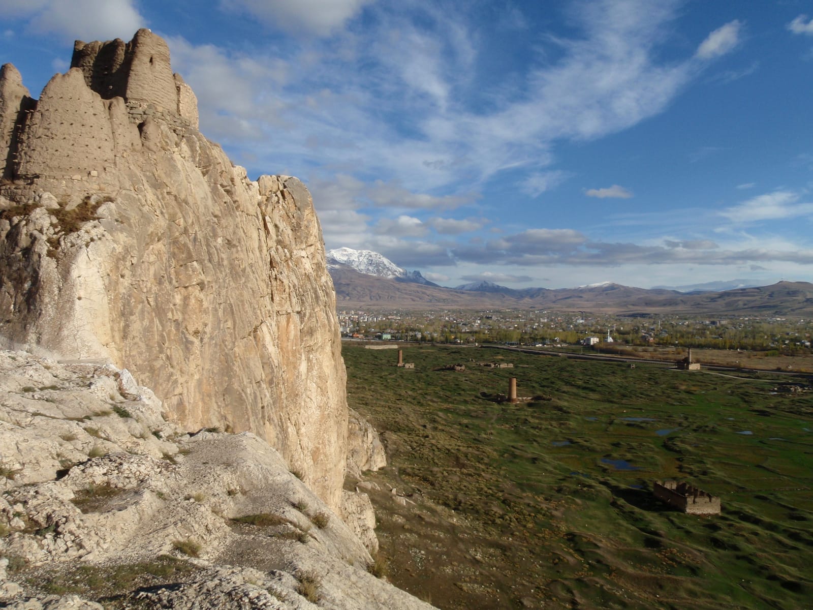
Tushpa — the ancient capital of the Urartian Kingdom — occupies a dramatic elongated rock outcrop rising steeply above the eastern shore of Lake Van, the largest lake in Turkey. The fortress served as the political and military center of Urartu from the 9th to 7th centuries BCE, when this powerful Iron Age kingdom controlled much of eastern Anatolia, the southern Caucasus, and northwestern Iran.

The Rock of Van stretches approximately 1,800 meters in length and rises to 80 meters above the surrounding plain. Its surfaces are carved with cuneiform inscriptions in both Urartian and Assyrian languages, recording royal achievements, building projects, and military campaigns. The most famous is the inscription of King Sarduri I (c. 840-830 BCE), the earliest known Urartian text, written in Assyrian cuneiform.

"Sarduri, son of Lutipri, built this wall."
— Cuneiform inscription of King Sarduri I, circa 830 BCE

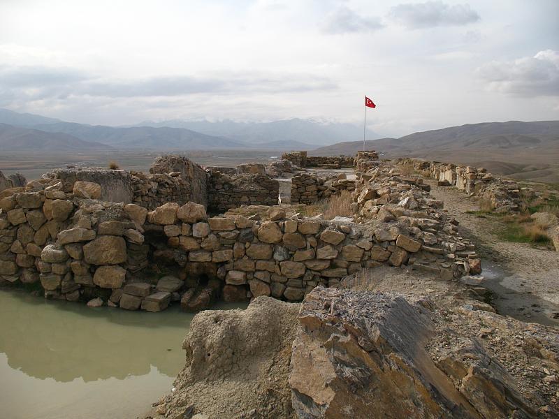
Rock-cut chambers honeycomb the fortress — including royal tombs, storage rooms, and ritual spaces. The Urartians built an elaborate canal system bringing water from distant mountains to the capital, a feat of hydraulic engineering that still impresses today. The Menua Channel, built by King Menua around 800 BCE, stretches over 50 kilometers and portions of it remain in use.

Below the fortress, a lower city sprawled along the lakeshore. The fortress continued in use through the Median, Achaemenid, Armenian, and Ottoman periods, with each civilization adding new layers of fortification and habitation.

Van from Van Kalesi
Van from Van Kalesi

Van from Van Kalesi | EvgenyGenkin (CC BY-SA 4.0)

The fortress architecture is characterized by massive cyclopean masonry, with stone blocks weighing several tons. Within the citadel, excavations have revealed the foundations of a temple dedicated to the chief Urartian god Haldi and extensive storage magazines for grain, oil, and wine, indicating centralized economic control. Daily life in the associated lower city, though less understood, would have supported artisans, traders, and a military garrison, with trade connections extending to Assyria for luxury goods and to the Caucasus for metals.

The kingdom's decline began in the late 7th century BCE, likely due to a combination of Scythian or Median incursions and internal instability. Tushpa was sacked, possibly around 590 BCE, ending its role as a royal capital. The site was later occupied by Achaemenid, Armenian, and Ottoman powers, who left their own inscriptions and modifications on the ancient rock.

Why It Matters

Tushpa is the defining monument of Urartian civilization — a kingdom that rivaled Assyria for dominance of the ancient Near East during the 9th-7th centuries BCE. The cuneiform inscriptions at Van Fortress provide the primary evidence for Urartian language, political organization, and royal ideology. The Urartian hydraulic engineering visible at Tushpa — particularly the Menua Channel — represents one of the oldest functioning water systems in the world, a testament to engineering knowledge that predates the Roman aqueducts by centuries. The fortress's dramatic setting above Lake Van makes it one of the most visually striking archaeological sites in Anatolia.

Stay curious

New stories and sites, once a month. No spam.

Evidence & Interpretation

Distinguishing what is well-established from what remains debated.

Well-Established Facts

3
  • Cuneiform inscriptions at Van Fortress identify the site as the capital of Urartu, with texts from multiple kings including Sarduri I, Menua, and Argishti I.
  • The Menua Channel, an aqueduct stretching over 50 km from the Engil River, is attested both by inscriptions and by its physical remains, portions still carrying water.
  • Rock-cut royal tomb chambers within the fortress have been excavated, though most were looted in antiquity.

Scholarly Inferences

1
  • The fortress rock was likely a sacred site before the Urartian period, given similar patterns of rock-citadel veneration across the ancient Near East.

Debated Interpretations

2
  • The extent and layout of the lower city at Tushpa remain poorly understood due to later overbuilding and limited excavation.
  • The function of the large, stepped niche known as the 'Mher Kapısı' (Gate of Mithra) is debated, with theories ranging from a royal throne platform to a religious altar or an astronomical observatory.

Discovery & Excavation

1827

First European documentation

Led by Friedrich Eduard Schulz

Friedrich Eduard Schulz copied the cuneiform inscriptions at Van Fortress, bringing Urartian civilization to scholarly attention.

1898–1901

German-British expeditions

Led by Carl Friedrich Lehmann-Haupt

Carl Friedrich Lehmann-Haupt conducted excavations and epigraphic studies, laying the foundation for Urartian studies.

1959–1990

Turkish excavations

Led by Afif Erzen

Afif Erzen and later Turkish teams excavated the rock-cut tombs, lower city, and canal systems.

2005

Conservation and documentation

Comprehensive conservation work on the inscriptions and rock-cut chambers, including 3D digital documentation.

More Photos

Museum Artifacts

Community Photos

Share your experience

Have you visited this site? Upload your photos to help others discover it.

Location

Related Sites

Sources

  • The Kingdom of Urartu in Eastern AnatoliaPaul Zimansky (1998)
  • Urartian StudiesMirjo Salvini (2008)
  • Wikipedia — TushpaLink

Research Papers

Stay in the loop

Get notified when we add new sites or major features. We send at most 1–2 emails per year. We never sell your email.

Atlas AnatoliaAtlas Anatolia

An interactive atlas of ancient Anatolian sites. Explore civilizations, monuments, and stories across millennia.

info@atlasanatolia.com

© 2026 Atlas Anatolia. Content is provided for educational purposes.

Map data © OpenStreetMap contributors