Atlas AnatoliaAtlas Anatolia
Roman theatre at Selge high in the Taurus Mountains

Selge

Altinkaya (Zerk)500 BCE – 700 CE
ClassicalHellenisticRomanByzantinePisidianGreekRoman+1Antalya

Elevation

~1,000 meters in the Taurus Mountains

Theatre Capacity

~10,000 spectators

Eurymedon Bridge

27-meter-high Roman arch over gorge

Peak Military

20,000 soldiers at height of power

Main Water Source

Fed by a sophisticated Roman aqueduct system from the Kestros (Aksu) River, over 20 km long.

Coinage

Minted its own silver and bronze coinage from the 5th century BCE until the 3rd century CE, often depicting the city's patron deity, Zeus.

Selge demonstrates how geography shaped political destiny in the ancient world.”

WFrom Wikipedia

Selge was a fiercely independent Pisidian mountain city in the Taurus Mountains, known for its Roman theatre and the spectacular Eurymedon Bridge spanning a deep gorge.

Read full article on Wikipedia

Overview

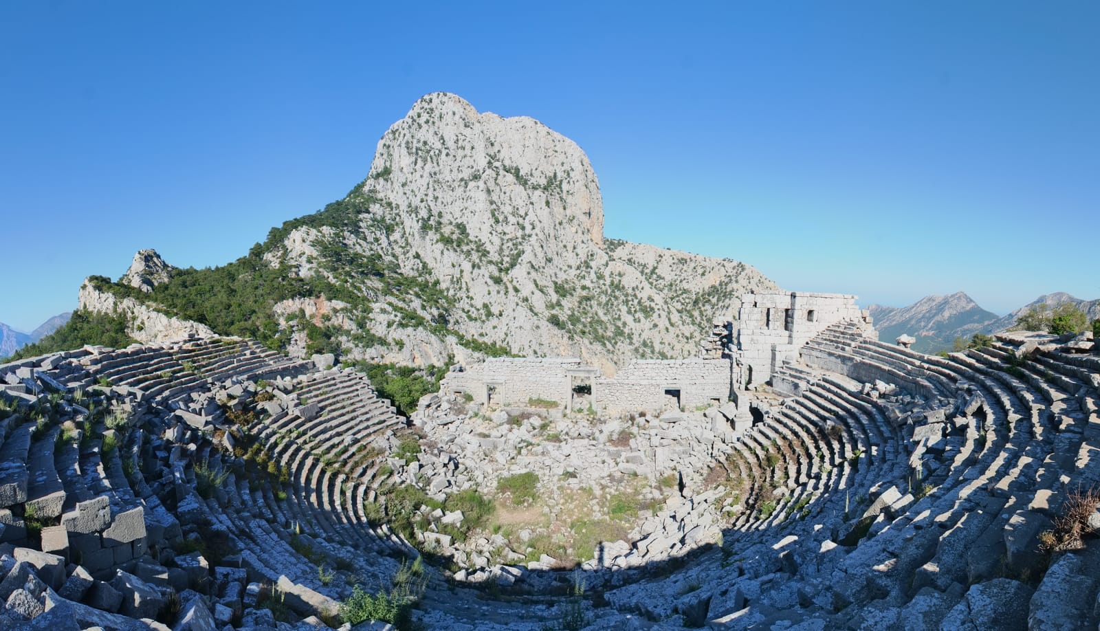
Selge was the most remote and fiercely independent city of ancient Pisidia, situated at approximately 1,000 meters elevation in the rugged Koprulu Canyon region of the western Taurus Mountains. The city's extreme isolation — accessible only through narrow mountain passes — allowed it to maintain its independence longer than almost any other Anatolian city, resisting both Persian and Hellenistic domination.

The city thrived on mountain resources: storax resin (used in perfumery and medicine), timber, and olives. At its peak, Selge fielded an army of 20,000 soldiers — remarkable for a mountain city — and minted its own coinage. The population is estimated to have reached 20,000 in the Hellenistic period.

"Selge is a city of Pisidia, situated on a well-fortified hill, with a river flowing beneath it."
— Strabo, c. 7 BCE - 23 CE

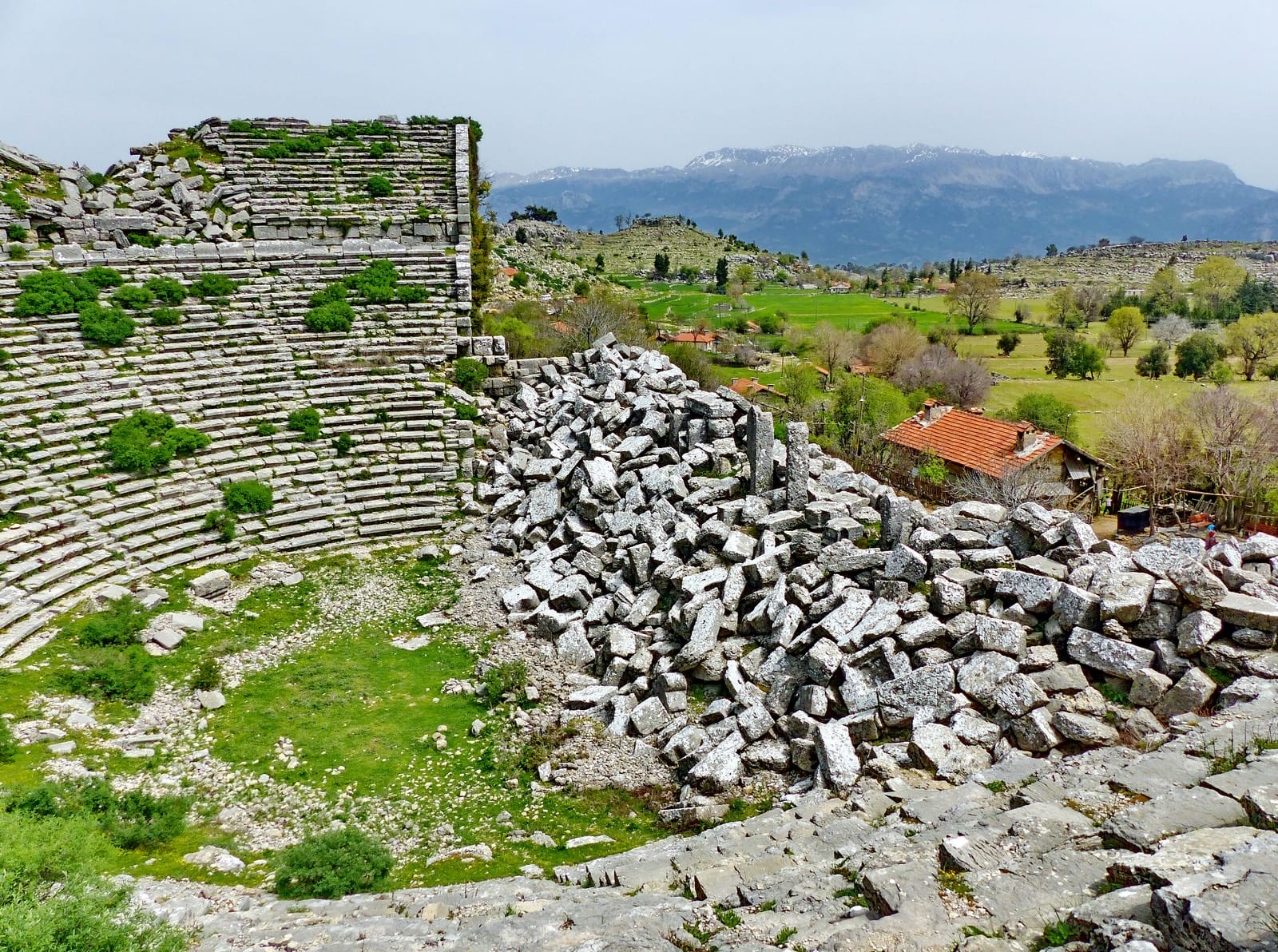
The well-preserved Roman theatre, seating approximately 10,000 spectators, occupies a spectacular hillside position with views across forested mountains. Below the city, the ancient Eurymedon Bridge (modern Oluk Bridge) — a single-arch Roman bridge spanning the Koprulu Canyon at a height of 27 meters — is one of the most photographed ancient bridges in Turkey.

The modern village of Altinkaya (formerly Zerk) sits among the ruins. The surrounding Koprulu Canyon National Park preserves the dramatic landscape of deep gorges, cypress forests, and rushing rivers that defined Selge's mountain world. The ancient city is reached via a winding mountain road that itself offers panoramic views of the canyon.

Selge Theatre Inside 5113

Selge Theatre Inside 5113 | Dosseman (CC BY-SA 4.0)

The city's urban fabric reveals a blend of Hellenistic planning and local Pisidian tradition. Beyond the theatre, the remains of a large agora, a stadium, two temples dedicated to Zeus and Artemis, and a monumental nymphaeum speak to a prosperous civic life. The extensive system of cisterns and aqueducts highlights the engineering required to support a major settlement in this arid, high-altitude environment. Selge's economy was not solely based on storax; its prolific coinage, minted from the 5th century BCE through the Roman Imperial period, facilitated trade and asserted its political autonomy. These coins often featured local symbols like the club of Heracles or the head of Artemis. The city's decline began in the 3rd century CE, likely due to regional instability and the changing dynamics of trade. It remained a bishopric into the early Byzantine era but was gradually abandoned, its formidable isolation eventually becoming a liability rather than a defense.

Why It Matters

Selge demonstrates how geography shaped political destiny in the ancient world. Its mountain fortress position enabled centuries of independence, creating a unique Pisidian cultural identity that resisted the homogenizing influences of larger empires. The Eurymedon Bridge is a masterpiece of Roman provincial engineering, demonstrating how the empire connected even its most remote communities through infrastructure. The city's economic model — based on mountain products like storax — shows how specialized local resources could sustain prosperity far from major trade routes.

Stay curious

New stories and sites, once a month. No spam.

Evidence & Interpretation

Distinguishing what is well-established from what remains debated.

Well-Established Facts

3
  • Polybius (5.73) records that Selge could field an army of 20,000 men, indicating a substantial population for a mountain city.
  • The Roman theatre at Selge is well-preserved with seating for approximately 10,000, consistent with a significant urban population.
  • Strabo (12.7.3) describes Selge as the largest city of Pisidia, thriving on storax, timber, and olive production.

Scholarly Inferences

2
  • The city's extreme mountain location and ability to resist Hellenistic armies suggests sophisticated fortification systems exploiting natural terrain.
  • The city's extensive terracing and cistern systems indicate a highly organized, self-sufficient agricultural and water management strategy to support its large population in a mountainous environment.

Debated Interpretations

1
  • The precise date and construction history of the Eurymedon Bridge — whether a single Roman construction or incorporating earlier elements — is debated.

Discovery & Excavation

1884

First European survey

Led by Karl Lanckoronski

Karl Lanckoronski documented the theatre, stadium, and other monuments during his survey of Pamphylia and Pisidia.

1970–1990

Survey and documentation

Various Turkish and international teams surveyed the site, mapping the urban plan and documenting the Roman bridge.

1994

Survey and Architectural Documentation

Led by Stephen Mitchell and the British Institute at Ankara

A comprehensive survey of the city's fortifications, public buildings, and necropolis was conducted, providing the first detailed plan of the urban layout.

2005

Theatre conservation

Conservation work on the Roman theatre and documentation of the surrounding urban remains including the agora and temple foundations.

More Photos

Museum Artifacts

Community Photos

Share your experience

Have you visited this site? Upload your photos to help others discover it.

Location

Related Sites

Sources

  • Stadte Pamphyliens und PisidiensKarl Lanckoronski (1890)
  • Selge: Archaeological Survey and ResearchJohannes Nolle (1993)
  • Wikipedia — SelgeLink

Research Papers

Stay in the loop

Get notified when we add new sites or major features. We send at most 1–2 emails per year. We never sell your email.

Atlas AnatoliaAtlas Anatolia

An interactive atlas of ancient Anatolian sites. Explore civilizations, monuments, and stories across millennia.

info@atlasanatolia.com

© 2026 Atlas Anatolia. Content is provided for educational purposes.

Map data © OpenStreetMap contributors