# Three Capitals, One Empire: The Ottoman Journey Through Anatolia
*An Editorial for Atlas Anatolia*
"I have built this mosque to rival the great Hagia Sophia."
Attributed to Mimar Sinan on the Selimiye Mosque (1575)
Beneath the modern bustle of Turkey lies a palimpsest of empires. Yet few narratives are as dynamically etched into the landscape as that of the Ottomans — a saga not born in a single, destined city, but one that unfolded across the Anatolian plateau, evolving with each new capital. This is not merely a story of conquest, but of adaptation, of an empire finding its voice, its faith, and its monumental identity through a profound dialogue with the land itself. Our journey follows the Ottoman state from a frontier principality to a world empire through three successive capitals — Bursa, Edirne, and the spiritual anchor of Konya — with a poignant pause in Safranbolu, a living testament to the empire’s enduring civic and domestic soul.
Bursa: The Cradle of Dynasty and the Green City**

20120604 Edirne view from the top of the Minaret of Selimiye Mosque Edirne Turkey Panoramic | User:Ggia (CC BY-SA 3.0)
Our story begins not with a bang, but with a protracted siege. In 1326, after a decade of blockade, the city of Prusa, a Byzantine jewel on the verdant slopes of Mount Uludağ, fell to the Ottoman bey, Orhan Gazi. This was no mere raid. The capture of Bursa marked the Ottomans’ decisive transition from nomadic marauders to rulers of a major urban center. They did not destroy it; they adopted and transformed it, making it the first official Ottoman capital.
Archaeology in Bursa reveals this foundational synthesis. The city became known as Yeşil Bursa (Green Bursa), not just for its gardens, but for the revolutionary turquoise and green tiles that would adorn its defining monuments. Orhan Gazi established the city’s core social and commercial blueprint: the külliye. This complex, centered on a mosque, integrated a soup kitchen (imaret), a theological school (medrese), a public bath (hamam), and a hospice. The **Orhan Gazi Külliye, built between 1339-1340, physically embedded the Ottoman ethos of welfare and community into the urban fabric.
But it is in the Yeşil Türbe (Green Tomb) and its adjacent Yeşil Cami* (Green Mosque), commissioned by Sultan Mehmed I (Çelebi) and completed in 1424, where the early Ottoman aesthetic finds its first breathtaking voice. The tomb’s exterior is sheathed in brilliant glazed turquoise tiles, a technique and artistry that point directly to imported masters from Timurid Central Asia. The interior is a symphony of ceramic art: a mihrab (prayer niche) of staggering complexity, and walls covered in floral and geometric çini (tiles) in deep blues, greens, and whites. These structures, rising from the ashes of the disruptive Timurid invasion (1402), were a statement of revival and permanence. They also established the imperial burial tradition; Bursa’s necropolises hold the simple, somber tombs (türbe*) of Osman and Orhan Gazi, and the more ornate ones of their successors, creating a sacred dynastic landscape.

Turkish postage stamp, Selimiye Mosque, Scott No. J61, issued 1913 | Unknown authorUnknown author (Public domain)
Bursa’s archaeological record is also profoundly economic. The Koza Han (Silk Cocoon Caravanserai), built by Sultan Bayezid II in 1491, stands as a monument to the industry that fueled the empire’s early wealth. Its two-story courtyard, lined with rooms for merchants and their goods, speaks to Bursa’s role as the terminus of the Silk Road, where Persian silk met European merchants. The city’s bustling bedestens (covered markets) further illustrate an empire built as much on commerce as on the sword.
**Edirne: The Crucible of Imperial Architecture
As the empire’s gaze turned westward, toward the Balkans and the looming challenge of Constantinople, the capital shifted. In 1363, Murad I captured Adrianople from the Byzantines. By 1369, he had moved his court to this strategic bridgehead in Thrace, renaming it Edirne. For nearly a century, until the fall of Constantinople in 1453, and for decades after, Edirne served as the staging ground and architectural laboratory for an empire preparing for world dominion.

Green Mosque-Yeşil Camii-Bursa - panoramio | Haluk Comertel (CC BY 3.0)
Edirne is where Ottoman architecture shed its provincial skin and experimented with the scale and spatial drama befitting a global power. The Eski Cami (Old Mosque, 1403-1414), with its austere, multi-domed prayer hall, reflects a conservative, Seljuk-influenced grandeur. Its interior is dominated by monumental, calligraphic inscriptions, emphasizing the power of the word.
Then came the revolutionary leap. The Üç Şerefeli Cami* (Mosque with Three Balconies, completed 1447), commissioned by Murad II, broke the mold. For the first time, a monumental central dome — 24 meters in diameter — was placed atop a square prayer hall, supported by a system of walls and piers. This was the critical trial run for the engineering that would later define the classical Ottoman style. Its name comes from its minaret with three separate balconies (şerefe*), another innovation symbolizing aspiration and reach.
But Edirne’s ultimate masterpiece, and the direct precursor to Istanbul’s Süleymaniye and Selimiye, is the **Beyazıt II Külliye (1484-1488). This vast complex on the banks of the Tunca River is an archaeological window into the Ottoman mind. It wasn’t just a mosque and school; it included a revolutionary Darüşşifa (hospital). Archaeological and textual evidence reveals this was a center for holistic, even proto-psychiatric care. Treatments included the use of music, water sounds, scents, and occupational therapy — a stunning testament to the sophisticated social consciousness the empire sought to institutionalize. The complex’s harmonious integration with the riverine landscape also shows a developing sensitivity to siting and environment.
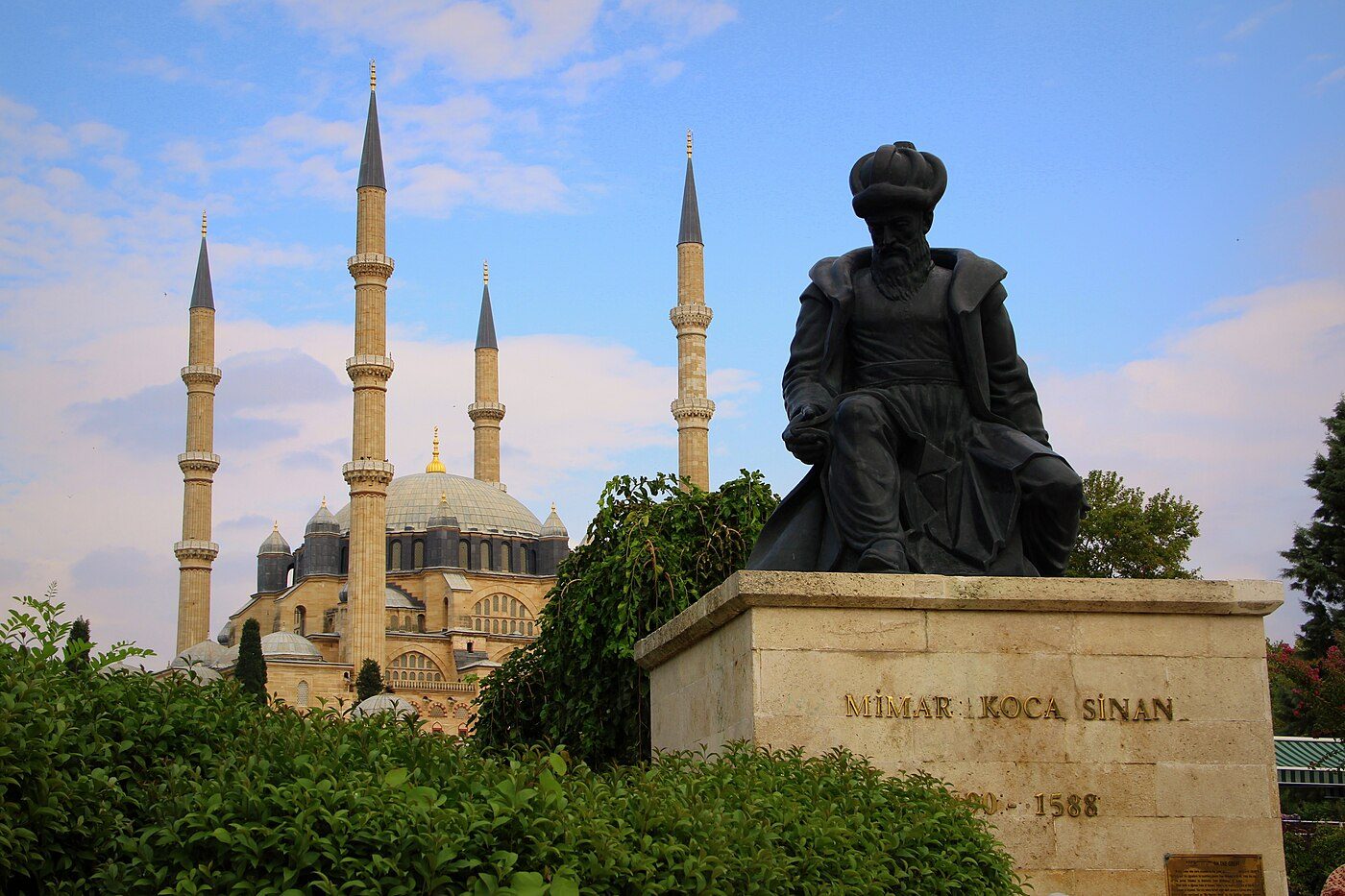
Edirne was the empire’s European workshop, where architects like Mimar Sinan (who would later build the sublime Selimiye Mosque there for Selim II between 1569-1575) honed their craft. The city’s archaeology is one of confident experimentation, a prelude to the conquest of the ultimate prize.
Konya: The Silent Partner – Anchoring an Empire in Sufi Soil
While Bursa and Edirne were political capitals, no understanding of the Ottoman journey is complete without a pilgrimage south, to the windswept plains of central Anatolia, to Konya. This was never an Ottoman capital in the administrative sense. It was something deeper: a spiritual and cultural wellspring.
Konya was the seat of the Seljuk Sultanate of Rum (1077-1308), whose refined court culture and monumental architecture provided a crucial template for the nascent Ottoman state. More importantly, it was the home and final resting place of Mevlana Celaleddin Rumi, the 13th-century mystic poet who founded the Mevlevi Order of Sufism, known as the Whirling Dervishes.
The Ottoman sultans, particularly after Selim I’s conquest of the Mamluk Sultanate in 1517, which brought the title of Caliph, became ardent patrons of the Mevlana Mausoleum (the Green Tomb, within the Mevlana Museum). They expanded and embellished the complex, covering Rumi’s sarcophagus and others in exquisite Ottoman-era velvet shrouds and adding a silver gate. This was not mere piety; it was strategic ideology. By aligning themselves with Rumi’s message of transcendent unity and the deeply rooted Mevlevi order, the Ottoman dynasty tapped into a powerful source of legitimacy and cultural cohesion across Anatolia. The Karatay Medrese (1251), with its stunning Seljuk-era tilework mihrab, and the İnce Minareli Medrese** (1265) stood as constant reminders of an earlier Turkish-Islamic golden age which the Ottomans saw themselves as continuing and surpassing.
Konya’s archaeology represents the bedrock of Turkmen and Seljuk identity upon which the Ottoman superstructure was built. It provided the religious vocabulary, the mystical fervor, and much of the artistic and architectural grammar that the Ottomans would later scale to imperial proportions.
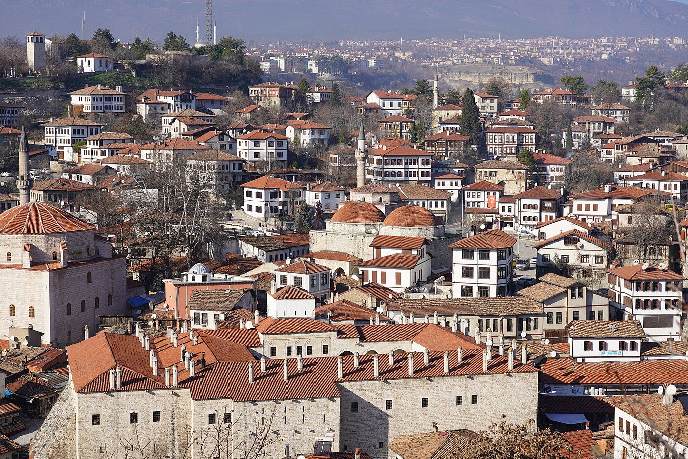
Safranbolu: The Empire’s Living Memory in Timber and Stone
Our journey concludes not with a capital, but with a home. **Safranbolu, a UNESCO World Heritage site nestled in the Black Sea region, is the preserved heartbeat of Ottoman civic life. While sultans plotted in palaces, the empire was sustained by its merchants, craftsmen, and civil servants. Safranbolu, thriving from the 17th to 19th centuries as a key stop on the Istanbul-Sinop trade route (notably for its prized saffron), became fabulously wealthy. Its citizens invested not in grandiose mosques, but in exquisite domestic architecture.
Walking Safranbolu’s cobbled streets is an archaeological experience in itself. The Ottoman Houses* here are masterpieces of vernacular design. Built on stone ground floors with cantilevered upper stories of timber and lathe-and-plaster, they are perfectly adapted to the terrain and climate. The hayat* (life) room, with its high ceilings, central fountain, and convertible seating areas, orchestrated family life. Intricately carved wooden ceilings, built-in cupboards, and stained glass windows speak of immense private wealth and refined taste.
The Cinci Han (a 17th-century caravanserai) and the Cinci Hamam (a vast bath complex from 1645) speak to the town’s commercial importance. The Köprülü Mehmet Paşa Mosque (1661) and the İzzet Mehmet Paşa Mosque (1796), while elegant, are modest in scale compared to imperial foundations. They blend seamlessly into a townscape dominated not by the state, but by the mercantile class. Safranbolu is the archaeology of the Ottoman Pax Ottomana — the peace and prosperity that allowed a distinct urban culture to flourish far from the centers of power. It shows us how the empire lived, not just how it ruled.
**Conclusion: An Anatolian Tapestry
The Ottoman Empire was not a monolith born fully formed in Istanbul. It was a process, an evolution written across the hills of Bursa, the rivers of Edirne, the spiritual plains of Konya, and the gentle slopes of Safranbolu. Each site represents a critical phase: Bursa gives us the nascent dynasty and its funerary and commercial foundations. Edirne reveals the ambitious empire testing its architectural and institutional wings. Konya provides the deep cultural and religious bedrock. Safranbolu** preserves the domestic and economic world that made the imperial project sustainable.
To trace this journey through Anatolia is to understand that empires are not just about palaces and conquests. They are about the synthesis of ideas, the adaptation of technology, the flow of commerce, and the quiet dignity of daily life. The stones of these cities tell a continuous story — of a people who emerged from the marches of Anatolia, absorbed the lessons of their predecessors, dared to innovate, and in doing so, shaped the course of history for over six centuries. Their journey is Anatolia’s journey, a legacy in tile, timber, and stone that awaits the curious traveler at every turn.