Atlas AnatoliaAtlas Anatolia
Ruins of the medieval city of Ani

Ani

500 CE – 1400 CE
34

Interest

W 44K
MedievalByzantineArmenianSeljukByzantineKars

Peak Population

~100,000+

Known As

City of 1001 Churches

UNESCO Status

World Heritage Site (2016)

Date Range

c. 500–1400 CE

Primary Construction Material

Local volcanic basalt and tuff stone

Major Historical Event

Sack of Ani by the Mongols under Ilkhanate commander Tamerlane in 1239 CE

Ani represents a remarkable example of medieval urban planning, religious architecture, and cultural exchange.”

WFrom Wikipedia

Ani is a ruined medieval Armenian city situated in Turkey's province of Kars, next to the closed border with Armenia. At its height around 1050 CE, the city may have had a population exceeding 100,000, rivaling Constantinople. It was known as the "City of 1001 Churches."

Read full article on Wikipedia

Overview

Ani is located in Kars Province, on a triangular plateau above the Akhurian River gorge that now forms part of the Turkish-Armenian border. In the 10th and 11th centuries, Ani was the capital of the Bagratid Armenian Kingdom and one of the most prosperous cities in the world.

At its height around 1050 CE, Ani may have had a population exceeding 100,000, rivaling the size of Constantinople. The city was known as the "City of 1001 Churches" and was a major center of Armenian culture, architecture, and commerce along the Silk Road.

"Ani is a great city, the capital of Armenia, with impregnable walls and a thousand churches."
— Ibn al-Athir (c. 1160–1233), Arab historian

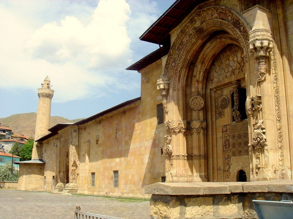
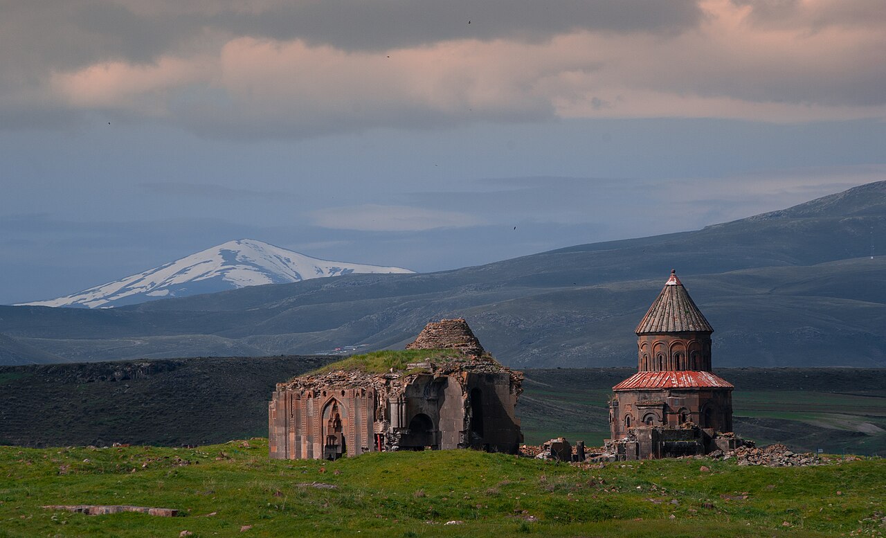
The site contains the ruins of numerous churches (including the Cathedral of Ani, built 989–1001), mosques, a Seljuk palace, defensive walls, and a citadel. The Church of the Redeemer (1035) and the Church of St. Gregory of Tigran Honents (1215), with its remarkable frescoes, are among the most notable structures.

Ani changed hands between Armenian, Byzantine, Seljuk, Georgian, and Ottoman rulers before being largely abandoned after Tamerlane's invasion in 1319 and a devastating earthquake in 1319.

Türkei, historische Stadt Ani, Erlöserkirche

Türkei, historische Stadt Ani, Erlöserkirche | Feldstein (CC BY-SA 4.0)

The city's formidable double walls, constructed under King Smbat II (977–989 CE), featured numerous semicircular towers and elaborate gates, demonstrating advanced military engineering. Within these defenses, archaeological evidence points to a thriving urban economy. Excavations have revealed workshops for metalworking, pottery, and glass production, alongside caravanserais that serviced Ani's role as a key node on east-west trade routes linking the Byzantine Empire, the Caucasus, and Persia.

Ani's decline was a protracted process. Following its capture by the Seljuk Turks in 1064 CE, it remained an important center but suffered from successive changes in rule, including the Georgian Kingdom, local Kurdish emirs, and the Mongols. The devastating sack by Tamerlane's forces in 1386, combined with a major earthquake in 1319 and the gradual shift of trade routes, led to the city's abandonment by the 18th century. Its ruins, preserved by the remote location, offer a poignant snapshot of a vanished medieval metropolis.

Why It Matters

Ani represents a remarkable example of medieval urban planning, religious architecture, and cultural exchange. Its churches demonstrate the sophistication of Armenian architecture, which influenced both Byzantine and later European building traditions. The city's multicultural history — with Armenian, Seljuk, Georgian, and Ottoman layers — makes it a powerful symbol of Anatolia's diverse heritage. UNESCO inscribed Ani as a World Heritage Site in 2016.

Stay curious

New stories and sites, once a month. No spam.

Evidence & Interpretation

Distinguishing what is well-established from what remains debated.

Well-Established Facts

3
  • The Cathedral of Ani was completed in 1001 CE by architect Trdat, who also repaired the Hagia Sophia dome.
  • The city served as the capital of the Bagratid Armenian Kingdom in the 10th–11th centuries.
  • The Church of St. Gregory of Tigran Honents (1215) retains extensive interior frescoes.

Scholarly Inferences

1
  • Ani's population may have reached or exceeded 100,000 at its peak, based on the extent of its ruins and historical sources.

Debated Interpretations

2
  • The relative contributions of earthquake damage versus deliberate destruction to Ani's decline are debated.
  • The original function of the structure known as the 'Church of the Shepherd' (Çoban Kilisesi) is debated, with some scholars suggesting it may have been a palace or civic building.

Discovery & Excavation

1892

First excavations

Led by Nikolai Marr

Nikolai Marr began systematic archaeological study of Ani.

1904–1917

Major Russian excavations

Led by Nikolai Marr

Extensive excavations during the Russian imperial period.

1965

Turkish Survey and Excavations

Led by Kemal Balkan and the Turkish Historical Society

A series of surveys and limited excavations were conducted by a Turkish team, focusing on documentation and clearing of major monuments.

2012

Turkish conservation project

Led by Turkish Ministry of Culture

Turkey began a major conservation and restoration program at the site.

More Photos

Museum Artifacts

Community Photos

Share your experience

Have you visited this site? Upload your photos to help others discover it.

Location

Related Sites

Read the full article on World History Encyclopedia
World History Encyclopedia · CC BY-NC-SA

Sources

  • Ani: World Architectural Heritage of a Medieval Armenian CapitalSeta Dadoyan (2015)
  • UNESCO World Heritage — AniLink

Research Papers

Stay in the loop

Get notified when we add new sites or major features. We send at most 1–2 emails per year. We never sell your email.

Atlas AnatoliaAtlas Anatolia

An interactive atlas of ancient Anatolian sites. Explore civilizations, monuments, and stories across millennia.

info@atlasanatolia.com

© 2026 Atlas Anatolia. Content is provided for educational purposes.

Map data © OpenStreetMap contributors